The black soil region in Northeast China functions as a core grain production area and a critical ecological barrier underpinning national food security. Long-term water erosion has thinned the black topsoil, depleted soil organic matter and reduced cropland productivity, emerging as a prominent constraint on sustainable agricultural development across the region. Systematically mapping long-term erosion dynamics, quantifying driving thresholds for risk escalation and projecting future multi-scenario risks are essential to support targeted black soil protection and zonal soil governance.
Recently, a research team led by Professor LI Lujun at the Northeast Institute of Geography and Agroecology, Chinese Academy of Sciences (CAS), carried out systematic cross-scale research to address these challenges. The team reconstructed spatiotemporal patterns of soil erosion intensity, sensitivity and integrated risk across the region from 1980 to 2020, quantitatively identified critical thresholds of key driving factors for marked erosion risk escalation across different geomorphic units, and simulated differentiated erosion risk patterns under three 2030 policy scenarios.
These two related studies were published in Ecological Indicators on Sep. 5 and Catena on Jun. 30, respectively.
This study is based on the RUSLE model. The research team has integrated multi-source geospatial datasets to reconstruct the spatiotemporal patterns of soil erosion intensity, sensitivity and integrated risk across Northeast China’s black soil region over the period 1980–2020. By coupling the GeoDetector model with the Pettitt non-parametric change-point test, the study has quantitatively pinpointed critical thresholds of key driving factors that trigger marked erosion risk escalation, broken down by geomorphic unit.
The results show that the regional high-risk center of soil erosion has shifted substantially over the four decades, migrating gradually from the Changbai Mountains to agricultural plains including the Songnen Plain and the Liaohe Plain. The regional average erosion modulus follows an overall trajectory of initial intensification followed by gradual mitigation. Soil erodibility in the Liaohe Plain displays an anomalous bimodal distribution, with both low- and high-erodibility zones each accounting for over 30% of the total area. This leaves the region highly vulnerable to abrupt erosion risk surges when subject to external disturbances.
Zonal threshold analysis indicates that 65% vegetation coverage is sufficient to effectively curb erosion in the western grassland subregion, whereas the eastern agricultural plains require coverage of more than 82%. The rainfall erosivity threshold for erosion onset in the western grassland stands at just 1,040 MJ·mm·hm⁻2·h⁻1·a⁻1, well below the equivalent figure for mountainous areas. GeoDetector analysis further confirms that the interactive explanatory power of soil erodibility and land use reaches 0.4979, far higher than that of any single factor, and that multi-factor synergistic amplification is the core mechanism driving the build-up of regional erosion risk.
Building on these findings, the team further coupled the RUSLE and PLUS models to quantify the driving effects of land use change on soil erosion, and simulated patterns of erosion risk differentiation under three 2030 policy scenarios: natural development, cropland protection and ecological protection.
The study finds that the black soil region has undergone dramatic land use transitions over the past four decades, with cropland expanding by 3.04 × 10⁴ km2; 41.2% of the newly added cropland has been converted from forestland and 38.7% from grassland. Soil conservation capacity varies markedly across land use types: bare land records the highest average erosion modulus at 2413.09 t·km-2·a-1, while shrubland exhibits the strongest erosion resistance.
Multi-scenario simulations indicate that indiscriminate cropland expansion at the expense of ecological space will cause irreversible black soil degradation. Coordinated protection of ecological land and optimized management of sloping cropland are essential to achieve both stable grain production and long-term soil and water conservation simultaneously.
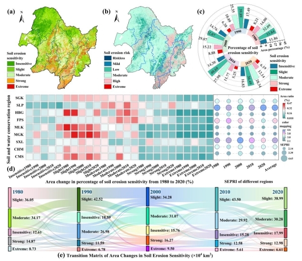
Figure 1. Spatiotemporal patterns and evolutionary characteristics of soil erosion sensitivity and potential risk in the black soil region of Northeast China, 1980–2020.
(Image by ZHANG Xuexian et al.)
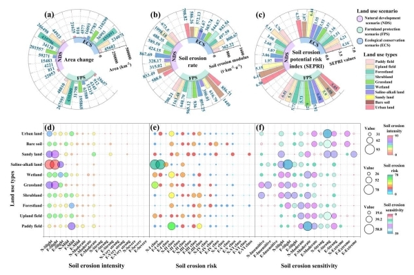
Figure 2. Projected soil erosion indicators under three land-use scenarios for 2030
(Image by ZHANG Xuexian et al.)
Contact:
LuJun Li
Northeast Institute of Geography and Agroecology, Chinese Academy of Sciences
E-mail: lilujun@iga.ac.cn
Reference:
Zhang XX, Wen YR, Chen J, He P, Li LJ*. Pattern reconstruction and threshold mutual feedback of soil erosion sensitivity and risk in the black soil region of Northeast China: A 40-year analysis based on RUSLE and GeoDetector. Ecological Indicators, 2026. doi: 10.1016/j.ecolind.2026.115442.
Zhang XX, Zhang JY, He P, Dai SS, Li LJ*. Soil erosion risk and prediction under land use changes based on RUSLE and PLUS models in the black soil region of Northeast China. Catena, 2026. doi: 10.1016/j.catena.2026.110371.
https://doi.org/10.1016/j.ecolind.2026.115442
https://doi.org/10.1016/j.catena.2026.110371


