Recently, the soil erosion research team led by Prof. Xingyi Zhang and Assoc. Prof. Mingming Guo from the Northeast Institute of Geography and Agroecology of the Chinese Academy of Sciences has made significant progress in quantifying the role of different land management practices in regulating slope runoff and sediments and assessing the applicability of the WEPP model in the Mollisols regions of Northeast China.
This study was published in Soil and Tillage Research on April 18.
Soil erosion, as a core driver of land degradation, poses a severe challenge to global agricultural sustainability, particularly in ecologically fragile yet critical grain production bases such as the black soil region of Northeast China. However, long-term monitoring studies on runoff and sediment yield under different land management practices remain scarce, and there is an even greater lack of model calibration and validation research aimed at mitigating land degradation.
According to the researchers, land management practices significantly affected runoff and soil loss, with the annual average losses ranked as follows: bare land (BL) > reduced tillage (RT) > conventional tillage (CVT) > contour tillage (CTT) > no-tillage (NT) > natural vegetation restoration (NVR). Implementing NT or CTT was recommended to mitigate soil erosion.
The spatial flux of runoff and sediment was significantly altered by the vegetation and the ridges-furrows system. Highly erosive rainfall was the dominant type of induced soil loss, highlighting its importance in ridge-furrow design.
Due to differences in soil erosion types, soil loss predictions for the BL, RT, and CVT practices were sensitive to rill erodibility, while NVR, NT, and CTT practices were sensitive to interrill erodibility.
High-resolution rainfall breakpoint data were used to minimize climate-induced errors in the WEPP model. Overall, the calibrated WEPP model effectively predicted both runoff depth and soil loss (NSE > 0.5), and predicted soil loss better than runoff depth. However, predictions for CTT were less satisfactory (NSE < 0.5), suggesting further model internal adjustments. This study is a foundational step toward optimizing land management and extending soil erosion predictions.
Key words: Ridge tillage; Runoff; Soil erosion; Natural rainfall; Land uses; WEPP; SIMWE
This study was supported by the Strategic Priority Research Program of the Chinese Academy of Sciences (XDA28010200), Young Scientist Group Project of Northeast Institute of Geography and Agroecology, Chinese Academy of Sciences (2023QNXZ03).
Contact:
Assoc. Prof. Guo Mingming
Northeast Institute of Geography and Agroecology, Chinese Academy of Sciences
E-mail: guomingming@iga.ac.cn
The full information of the article:
http://doi.org/10.1016/j.still.2025.106601
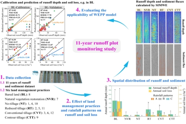
Fig. 1 Effects of different land management practices on slope runoff and sediment control and evaluation of WEPP model applicability in the Mollisols regions of Northeast China
